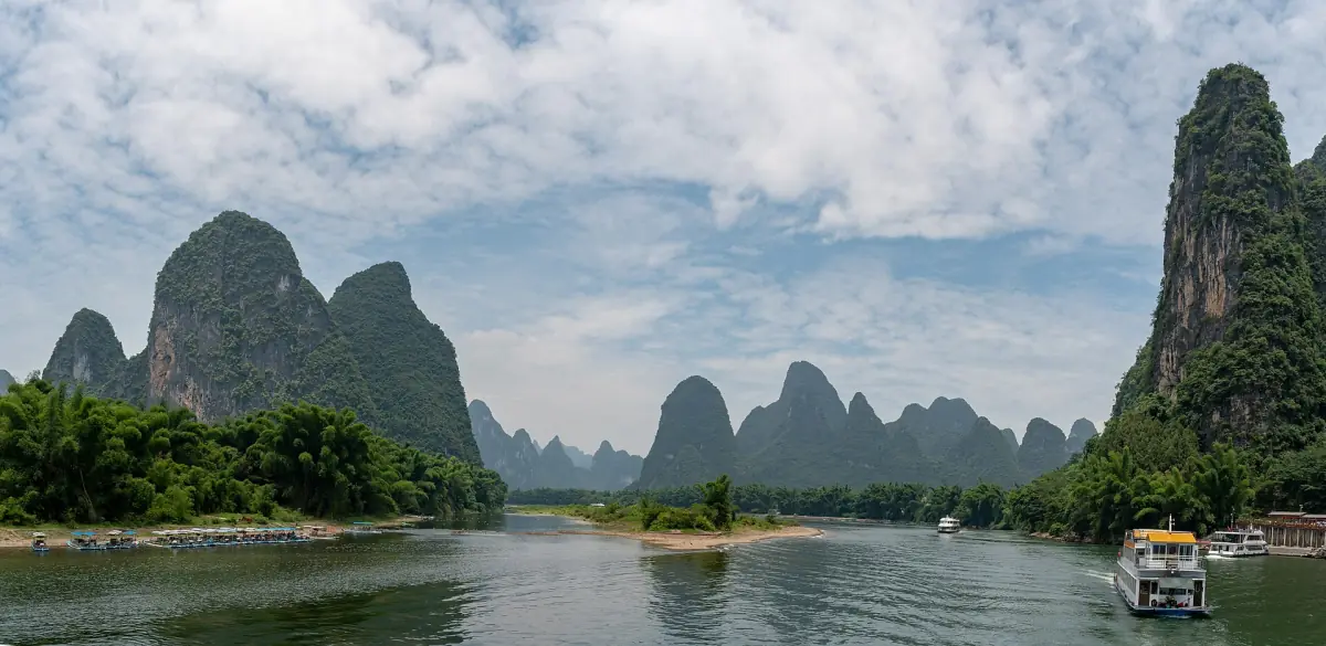
The Guilin mountains at a glance
The Guilin mountains are not a single range but many separate hills rising out of flat land and water. Geologists call this karst. In the Guilin basin, UNESCO describes two main forms: tower karst (fenglin), where hills stand alone on the plain, and cone karst (fengcong), where cones grow out of a shared base. Water flowing into the basin played a large part in shaping both.
This is the Guilin landscape that people come to see, and a good way to see it is from the water. A Li River cruise from Guilin to Yangshuo runs about 61 km between the hills, and the views change around every bend.

How the karst hills formed
Karst is a landscape shaped by water. In the Guilin basin, water flowing in from the surrounding areas worked on the rock over a long time and left the hills you see today. Where a hill stands alone on the plain, it is tower karst (fenglin). Where several cones grow out of a shared base, it is cone karst (fengcong). Both forms occur in the Guilin basin, and the river runs past both.
There is no single age for all the hills around Guilin. Different parts of the South China Karst formed at different times, and a figure from one area does not carry over to each hill on the Li. What you see on the river is the result of a long process, not one event.
The same water also works underground. Caves such as Reed Flute Cave in Guilin and Silver Cave in Lipu are the hollow side of the karst. At Silver Cave, about 20 km from Yangshuo, a path of roughly 2,000 m leads through a lower cave, a hall and an upper cave.
Key dates and figures
| Date or figure | What it means |
|---|---|
| 214 BC | Lingqu Canal completed under Qin Shihuang |
| About 36.4 km | Total length of the Lingqu Canal |
| 2007 | First inscription of the South China Karst as World Heritage |
| 2014 | Guilin karst added in the extension |
| 164 km | The Li River section proper, from the Lingqu mouth to the Lipu and Gongcheng mouths |
| About 61 km | Cruise stretch from the Guilin piers to Yangshuo |
For most visitors, the cruise between Guilin and Yangshuo is a good single trip if the karst landscape is what you came for: it covers the core of the river stretch in one day.
Our pick for the culture
This small-group day visits a minority village alongside the terraces.
Hand-picked tours, booked through Viator. Prices are indicative starting prices in US dollars (as of October 2026). Tap a tour for live availability and the current price in your currency.

See the karst landscape on the Li River
Cruises from Guilin to Yangshuo and day tours through the karst hills, with live prices and availability.
UNESCO South China Karst
The South China Karst is a serial World Heritage site: several separate areas inscribed together. It was first inscribed in 2007, and Guilin karst was added in the extension of 2014. Within Guilin, UNESCO names two components, Putao and Lijiang. Not all of Guilin and not every attraction in the region is World Heritage.
The listing comes with duties. UNESCO asks for protection of the river catchments and water quality and for limits on the harm done by tourism and building. Environment, water, city and county authorities work together in the catchment, and the Maritime Safety Administration can close stretches of the river to boats.

The Li River from source to Yangshuo
The Li River (Li Jiang) rises at Mao'er Shan and belongs to the upper course of the Gui Jiang in the Pearl River system. The section called the Li proper is 164 km long. It starts in the north where the Lingqu Canal joins and ends in the south at the mouths of the Lipu and Gongcheng rivers. Upstream the river is called Darong Jiang, downstream Gui Jiang.
The tourist stretch is only part of this. Cruise boats run about 61 km from the Mopanshan and Zhujiang piers outside Guilin to Longtoushan or Shuidongmen in Yangshuo. Do not confuse the Li River with the city of Lijiang in Yunnan, which is a different place.
The Lingqu Canal: linking two great rivers
The Lingqu Canal in Xing'an links the Xiang and Li river systems and through them the basins of the Yangtze and the Pearl River. It was completed in 214 BC under Qin Shihuang and is about 36.4 km long.
Since then the Li River has been part of a water route between the Yangtze and the Pearl River basins. The canal is on China's UNESCO Tentative List, which means it is a candidate. It is not an inscribed World Heritage site in its own right.
The Guilin landscape in painting and poetry
The hills and river around Guilin have long been a subject of Chinese literature and painting. Classical poems praise the river and its peaks, and painters have returned to the motif again and again. It even appears on a banknote.
One example is the back of the 20 yuan note. Its scene shows the river landscape near Xingping, with Yuanbao Shan in the background.
Inside Guilin, hills such as Elephant Trunk Hill and Fubo Hill stand between the houses and rivers. Our Guilin page covers the city sights and their opening hours.

Guilin mountains: frequently asked questions
Why do the Guilin mountains look so unusual?
They are karst: hills shaped by water into separate towers and cones. In the Guilin basin both tower karst (fenglin) and cone karst (fengcong) occur, often close together.
How did the Guilin mountains form?
The Guilin mountains formed as karst: water flowing into the Guilin basin worked on the rock over a long time and left separate tower hills (fenglin) and cone hills (fengcong). It was a long process, not a single event.
How old are the karst hills of Guilin?
There is no single age that applies to all of them. Different parts of the South China Karst formed at different times, so avoid one figure for every hill.
Is the Li River a UNESCO World Heritage site?
Guilin karst became part of the South China Karst in 2014, with the components Putao and Lijiang. Not every place in the region is included.
What is the Lingqu Canal?
A canal in Xing'an that links the Xiang and Li rivers and thus the Yangtze and Pearl River basins. It was completed in 214 BC under Qin Shihuang and is about 36.4 km long.
Where is the view from the 20 yuan note?
On the river near Xingping, with Yuanbao Shan in the background. Details are on our Xingping page.